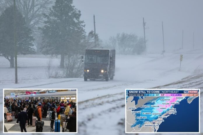
Albany, New York—Millions of residents are finally feeling the first major snow of the season as a powerful nor’easter drifts up the East Coast. The storm brings a mix of rain, ice, and snow to the densely populated northeast section of the I‑95 corridor, potentially worsening travel issues left over from the Midwest blizzard that hit just days earlier—right as La Niña kicks off its winter pattern for the year.
A fast‑moving low‑pressure system has bounced off the Southeast and is advancing along the coast ahead of schedule. Weather models from the Fox Forecast Center show an abrupt shift from rain to snow just inland of I‑95, creating a sharp line between the two precipitation types.
New Jersey Governor Phil Murphy activated a State of Emergency at 5:00 a.m. ET on Tuesday, citing the severe impacts the storm is expected to impose.
Coastal temperatures are likely too warm for snow along the shoreline, yet the heavy rains scheduled for Tuesday could delay flights at major airports in Washington, DC; Philadelphia; Newark; New York City; and Boston.
The core of the forecast remains consistent for inland regions stretching from the Ohio Valley through interior New England. Winter Storm Watches cover central and upstate New York, western Massachusetts, southern Vermont, southern New Hampshire, and southern Maine. Alerts are in effect from the Ohio Valley all the way to Maine.
Moisture and cold air are expected to produce 1–3 inches of snow across Ohio, Pennsylvania, upstate New York, and much of New England, while middle New York, Vermont, New Hampshire, and Maine could see 5–8 inches. Snowfall will be higher in the Adirondacks, Green, and White mountain ranges through Wednesday morning.
The exact position of the rain‑to‑snow line matters for drivers. Predictions indicate anywhere from a thin coat to a quarter‑inch of ice could appear on roads in the Appalachians, especially in West Virginia and Virginia. Higher elevations in Pennsylvania, northern New Jersey, New York’s Mid‑Hudson Valley, and Connecticut might also experience icy conditions. Even a small amount—just a quarter of an inch—can be hazardous for motorists and pedestrians.
In the south, icy patches are forecast for the mountains of western North Carolina, a region still healing from last year’s Hurricane Helene.
The low‑pressure system is expected to hold its ground for a few more hours before clearing by Wednesday morning. A new surge of colder Arctic air could then arrive by Thursday, potentially causing slick roads during morning commutes.
Historically, La Niña tends to increase the frequency of nor’easters along the Eastern Seaboard, a fact underscored by the numerous coastal storms last fall. NOAA projects that U.S. conditions may shift back to neutral around the start of January.
Stay informed on all the latest news, real-time breaking news updates, and follow all the important headlines in world News on Latest NewsX. Follow us on social media Facebook, Twitter(X), Gettr and subscribe our Youtube Channel.


